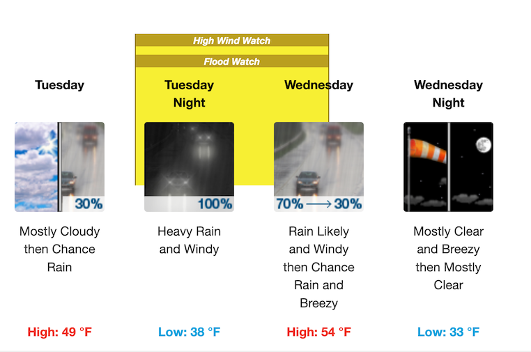
WARWICK, RI— The snowstorm’s passed, leaving 5.6 inches of snow at TF Green Airport and Warwick Schools with an hour delay, no pre-K, but now there are Wind and Flood Watches as heavy rain and strong wind comes Tuesday night.
Many cities and towns called a one hour delay for schools this morning, with the exception of Coventry, which announced a two hour delay. Trash pickup continues as usual this morning, Mayor Frank Picozzi announced on his Facebook page. While RIDOT and Warwick DPW were widening and cleaning up the streets overnight, Picozzi warned citizens to be wary of icy roads today.
“With rain predicted later in the week it’s important to get the drains cleared,” Picozzi noted in his messages about storm cleanup.
Wind and Flood Watches in effect Tuesday night
That rain will come in big doses, driven by strong winds, with the possibility of power outages, according to the National Weather Service.
Wind watch: Starting at 7 p.m. tomorrow, southeast winds will reach 30 to 40 mph with gusts up to 60 mph possible across Rhode Island and portions of eastern, northeastern and southeastern Massachusetts. Damaging winds could blow down trees and power lines, and travel will likely be difficult, especially for high-profile vehicles: trucks, vans, SUVs, or any vehicles towing a trailer, as these are more prone to be pushed or even flipped by high wind gusts.
Flood watch:Coinciding with the high winds, heavy rain is expected, which, combined with the resulting snowmelt. This is likely to result in excessive runoff, flooding of rivers, creeks, streams, and other low-lying and flood-prone locations. Creeks and streams may rise out of their banks. Flooding may occur in poor drainage and urban areas. Storm drains and ditches may become clogged with snow.
FLOODING RAIN
Prepare for rainfall flooding having possible extensive impacts within southern New England. Potential impacts include:
- Major rainfall flooding may prompt many evacuations and rescues, especially in urban areas. – Rivers and tributaries may rapidly overflow their banks in multiple places.
- Small streams may become dangerous rivers.
- Streets and parking lots become rivers of moving water with underpasses submerged.
- Driving conditions become dangerous.
- Many road and bridge closures with some weakened or washed out.
DAMAGING WIND
Prepare for dangerous wind with significant impacts near the South Coast, Cape Cod, and the Islands. Potential impacts in this area include:
- Some damage to roofing and siding materials, along with damage to porches, awnings, carports, and sheds.
- Several large trees snapped or uprooted, but with greater numbers in places where trees are shallow rooted.
- Some roads impassable from large debris, and more within urban or heavily wooded places.
- A few bridges and access routes impassable.
- Power and communications outages possible, but more prevalent in areas with above ground lines.
EMERGENCY ALERTS:
RIBA – Make sure you’re signed up for text alerts from the Rhode Island Broadcasters Association. You’ll get emergency notifications (including school closings and delays) direct to your phone or email.
TF Green Airport – Click here to follow arrivals and departures at TF Green.
Emergency Calls:
- In an emergency, dial 911
- Police Department: 401-468-4200
- Fire Department: (401) 468-4000
- Highway Dept.: 401-738-2000 ext. 6518
- Do NOT call 911 to report a power outage. Contact National Grid at 1-800-465-1212. Smartphone users can also text STORM to NGRID (64743) for outage alerts. To check the status of outages in your area, visit RI Energy’s Power Outage Map for Rhode Island.
Listen to NOAA radio: Check the National Oceanic and Atmospheric Administration radio frequency here.
Author: Rob Borkowski
Rob has worked as reporter and editor for several publications, including The Kent County Daily Times and Coventry Courier, before working for Gatehouse in MA then moving home with Patch Media. Now he's publisher and editor of WarwickPost.com. Contact him at editor@warwickpost.com with tips, press releases, advertising inquiries, and concerns.
This is a test