Update: Feb. 15, 12:10 p.m.:
Snow has ended, but Governor Gina M. Raimondo is asking Rhode Islanders to stay off roads to give crews time to clear streets.
The Governor also reminded people about the predicted high winds and wind chill dipping to -10 to -20 degrees across the state today. Wind chills are expected to dip as low as -30 tonight.
A blizzard warning remains in effect until 7 p.m.
Update: Feb. 15, 12:44 a.m.:
McDermott Pool, the therapeutic pool and the Thayer and Warburton ice rinks are closed today.
Trash and recycling is expected to remain on schedule for Monday, Feb. 16.
Feb. 14, 8:28 a.m. Warwick, RI — Now it’s just getting absurd.
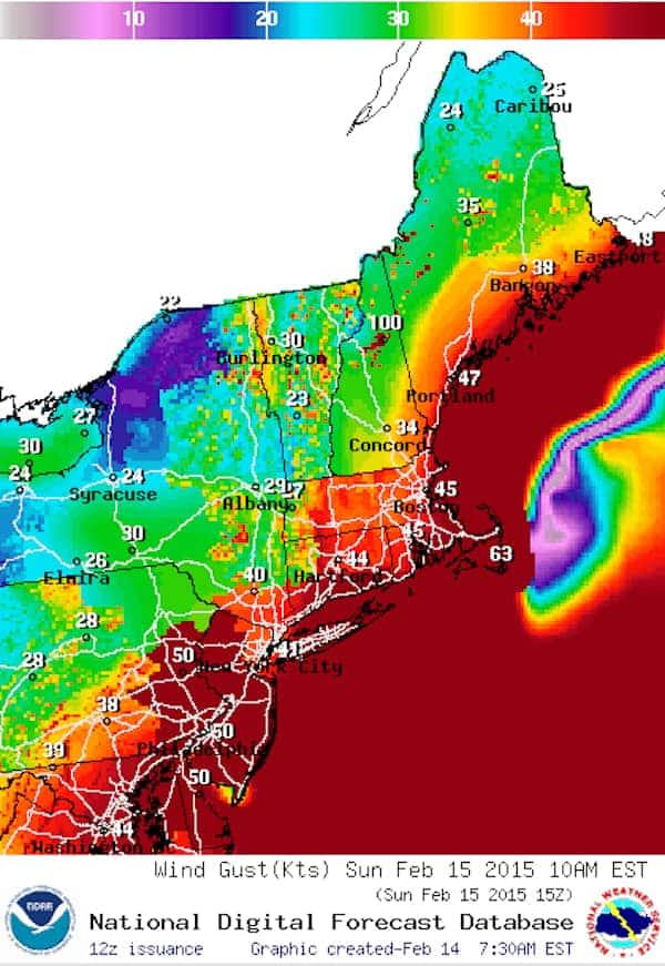
Yet another powerful winter storm — this one intensifying offshore and bringing hurricane-speed winds to the Massachusetts coast — is expected to move through the area Saturday afternoon through Sunday night, according to the National Weather Service.
The latest system, named Neptune by The Weather Channel, could bring up to a foot of snow to the Boston metro area, with even higher accumulations expected on the Maine coast.
In Rhode Island, NWS is forecasting the storm to bring between 6 and 10 in. to most areas starting after 1 p.m., adding another layer to the 15.8 in. that have fallen since Feb. 1 and the 42.3 in. of snow recorded at T.F. Green State Airport since Dec. 1.
But the real threat this time around is the high winds expected to sweep through the storm zone, with 55 mph gusts possible and wind chills falling to -29 degrees, the agency reported in its Blizzard Warning for Feb. 14 and 15.
This raises the possibility of electrical outages — and a reminder of how to handle them.
First, do NOT call 911 to report a power outage.
Instead, contact National Grid at 1-800-465-1212. Smartphone users can also text STORM to NGRID (64743) for outage alerts. To check the status of outages in your area, visit National Grid Outage Central for Rhode Island.
Also be sure to check batteries for radios, and charge up your cell phone in case of power loss.
By now, we’re all used to the incoming winter storm drill — here it is once again:
Parking ban: The Warwick Department of Public Works has issued a parking ban until further notice.
Emergency Alerts:
RIBA – Make sure you’re signed up for text alerts from the Rhode Island Broadcasters Association. You’ll get emergency notifications (including school closings and delays) direct to your phone or email. Check closings and delays here.
CodeRED – The City of Warwick has instituted a new rapid emergency notification service called CodeRED®. The new system will distribute emergency messages via telephone to targeted areas or the entire City of Warwick. Register here.
TF Green Airport – As of 8:15 a.m. Saturday morning, several flights were already delayed, with others expected once the storm system reaches the area. Click here to follow arrivals and departures at Green.
Emergency Calls:
- In an emergency, dial 911
- Police Department: 401-468-4200
- Fire Department: (401) 468-4000
- Highway Dept./Snow removal – 401-738-2000 ext. 6518
- Serve RI is looking for volunteers to help neighbors in need shovel out after upcoming snowfall. You can sign up here. You can ask for their help at at 401-331-2298. For all other needs, people should call United Way-2-1-1.
Listen to NOAA radio: Check the National Oceanic and Atmospheric Administration radio frequency here.
Editor’s Note: This article has been revised to include snowfall totals since Jan. 1 and Dec. 1.
Author: Joe Hutnak - editorjoe.warwick@gmail.com
Co-Founder and Editor-at-Large of Warwick Post. For Warwick Post-related inquiries or communications, email editorjoe.warwick@gmail.com
This is a test
This was the first time a weather-related headline made me laugh. Kudos to the author.
All the credit for that goes to Joe. We’re here all week. Try the veal.